Case Selection

Case selection for LASSO-ENA went through a careful selection process. An early scientific consideration was on sampling from the wide variety of the ENA cloud regimes, enabling LASSO-ENA simulations to enhance studies on the mesoscale organization and cellular structure of marine boundary clouds. The need to simulate many events for those science drivers also needed to be balanced by the requirements for an efficient use of ARM computing resources, including considerations for representative ensembles useful for detailed cloud process studies at relevant model domain size, grid scale and microphysical complexity.

The LASSO-ENA scenario (64 cases, with a core of 24-hour 6-member ensemble simulations) was divided across three marine boundary layer stratocumulus organizational categories found over the site: 1) closed cell stratocumulus organization (20 cases), 2) open cellular cloud organization (23 cases), and 3) a transitional or hybrid organizational mode (21 cases) that exhibited frequent clouds over the ENA site, but less well-defined spatial or continuous open/closed behaviors. Datasets were collected at the ENA site starting from its origin in late 2014 and considered cases until late 2022. Of the 64 cases, there were 51 unique “events” (i.e., 14 represented sequential days).

MODIS AQUA Satellite true color image showing LES model domain boundaries in relation to the ENA main site location and the scene associated with the 5 degree model forcing domain

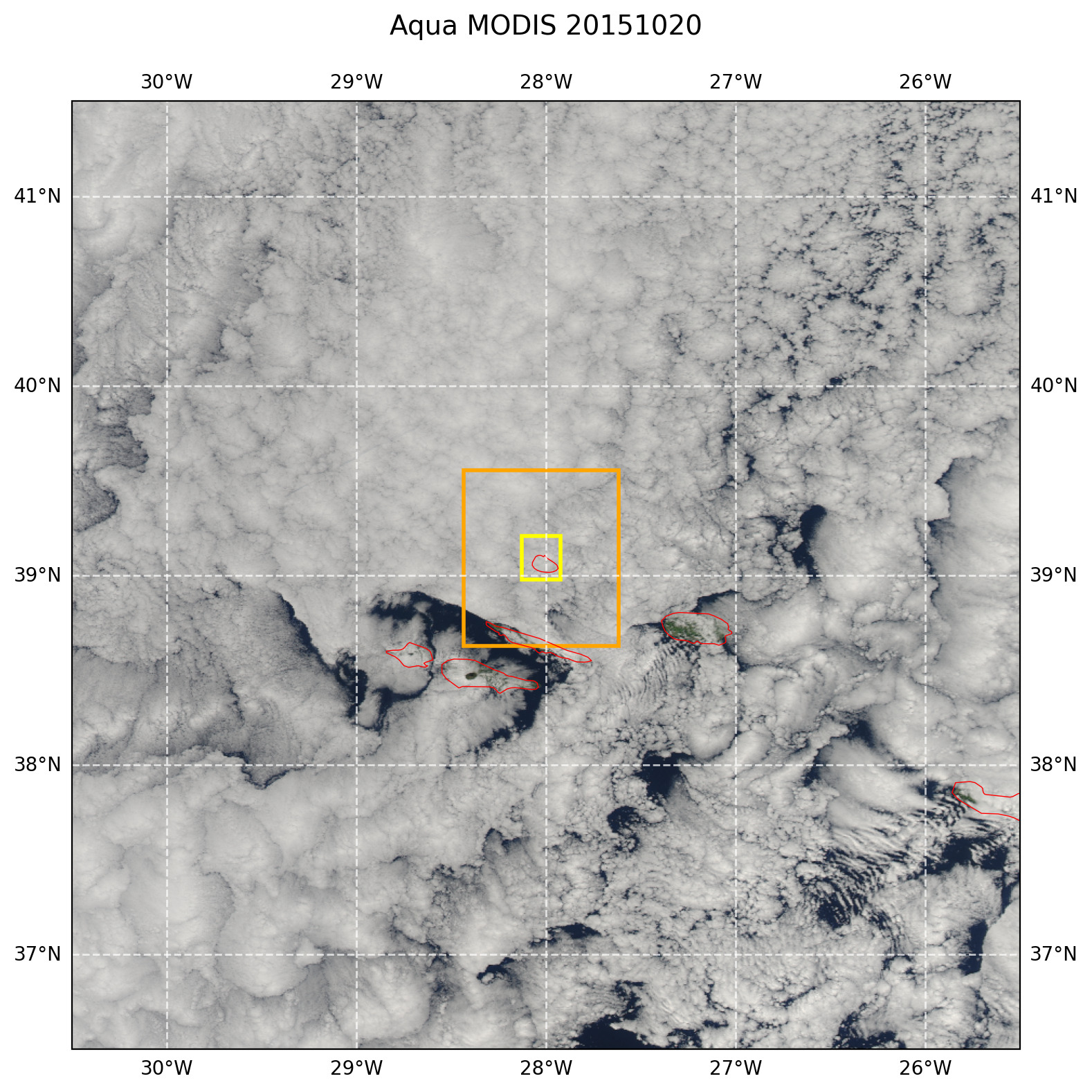
Figure 2 Illustration of the ENA LES small and large model domains relative to the main site location and the 5 degree model forcing scene.

The case selection process at ENA consisted of a few key steps:

First, a list of candidate dates was obtained from a variety of sources, including community recommendations, expert- or ENA literature identified case lists, and objective cloud regime classifications developed within ARM [Tian et al., 2025]. Our primary reference when narrowing case selection was ARM-profile and satellite imagery analysis, including cloud type definitions determined by column-radar time-height cloud property checks using ARM ARSCL products as found in Rémillard et al. [2012] and Sookdar et al. [2025], or spatial cloud coverage checks (visible imagery from SEVIRI or polar orbiting Aqua and Terra satellites) similar to Jensen et al. [2021]. Several cases exhibited “closed-cellular” conditions for a column-type perspective over the ENA site however lacked contiguous cloud coverage over larger O(100–400) km domains. For LASSO-ENA, these events were typically defined under “transitional/hybrid” as compared to characteristic “closed cellular” cases. In agreement with recent studies including Naud et al. [2016] and Ghate et al. [2020], the common LASSO-ENA “open cellular” events were identified under colder-season and post-frontal conditions, having cold-air outbreak characteristics. This LASSO-ENA selection did not identify a summertime (JJA) open cellular event. Only a small number of summertime closed cellular events were identified in the final scenario cases. Late shoulder season events found in the final record were often classified as “transitional” organization, sometimes reflecting a mixture of open and closed cellular behaviors within a given day or sequence of days.

A second, interwoven selection criteria was based on the quality of the ARM ENA datasets associated with the identified cases. Case selection priority was given by the LASSO team to days during ENA field campaigns [e.g, ACE-ENA Wang et al., 2022] or relevant sitewide activities. These times typically offered additional aircraft and/or radiosonde launches, advanced scanning radar and profiling capabilities, and other complementary products that could enrich anticipated studies. Events having additional radiosonde launches in common with the ACE-ENA field campaign, NPOESS validation efforts, and/or the GNSS ground station campaign during the ENA record were typically included, however this rarely was a deciding factor over suitability of cloud regime type and properties. Similarly, timeframes that had available scanning radar assets (SACR, XSAPR) were given priority, however the highest-quality scanning radar availability was often also associated with ACE-ENA campaign windows. Accordingly, suitable events would have been favored as having ARM AAF Gulfstream-1 aircraft and/or more frequent radiosonde (4/day) launches.

A third consideration tied to community recommendations was to place emphasis on prioritizing events having boundary layer winds directed from a northerly direction (approximately 315 to 90 degrees). This suggestion is found in multiple observational studies at ENA because this site sits at the northwest edge of Graciosa Island. The northerly wind directions have been suggested to partially mitigate the potential role that island terrain (Graciosa and surrounding) may lead to enhanced/suppressed ENA cloud properties in site observations [e.g., Ghate et al., 2021, Giangrande et al., 2019]. Overall, LASSO-ENA prioritized case selection for “oceanic” wind direction first, however the final library includes several events having southerly and/or westerly flows. Recent longer-term ENA studies as in Sookdar et al. [2025] have suggested the uncertainty of key observations LASSO uses under these flows (i.e., cloud fraction, LWP, COD) often falls within the uncertainty expected for instrument ability to sample those fields.

With respect to aerosol conditions and their role on case selection, the LASSO-ENA ensembles include 3 different aerosol loading configurations (low, mean, high). These levels were not specified for each case individually, but determined using the statistical aerosol behaviors for Aitken and Accumulation mode peaks across a multi-year ENA record. Additional information on the aerosol distribution properties and their estimation be found in the Modeling Methodology Section. Breakdowns for aerosol properties according to the event type and larger-scale synoptic conditions were performed, with the selected levels determined as suitable to capture the spread of possible site conditions.

Closed Cellular Stratocumulus Events

Table 2 Case dates selected for LASSO-ENA for its closed cellular stratocumulus events.

Case

Date

Description

1

2015-10-20

  • Extensive stratocumulus cloud event under easterly winds

  • Multiple periods having radar signatures of subcloud drizzle

  • Episodic breaks in the cloud field north of the islands

  • 5-day air mass back-trajectory from the U.S. northern central plains

2

2016-03-01

  • Widespread stratocumulus under southerly low-level flow

  • Increasing presence of subcloud precipitation after midday

  • 5-day air mass back-trajectories originated over the central North Atlantic

3

2016-03-08

  • Drizzling, asymmetric stratocumulus deck associated with southerly flow

  • More intense drizzle was observed around midday

  • The 5-day air mass back-trajectories originated in the central North Atlantic

4

2016-07-02

  • A drizzling stratocumulus deck under northeasterly flow

  • The strongest drizzle signatures occurred prior to midday

  • The cloud deck showed signs of erosion prior to 12 UTC, but re-established itself quickly and persisted throughout the remainder of the event

  • The 5-day air mass back-trajectories originated in the western North Atlantic

5

2016-10-15

  • A widespread stratocumulus deck

  • Low-level flows were from the northeast and east

  • The 5-day air mass back-trajectory originated over the U.S. plains via the central Atlantic

6

2016-11-15

  • A multi-day stratocumulus event with an interval of open cell type conditions

  • Ubiquitous precipitation observed throughout the event

  • 5-day air mass back-trajectories originating near Nova Scotia

7

2016-11-16

  • A multi-day stratocumulus event with an interval of open cell type conditions

  • Ubiquitous precipitation observed throughout the event

  • 5-day air mass back-trajectories originating near Nova Scotia

8

2016-11-19

  • Stratocumulus with embedded stronger precipitating cells

  • Northwesterly low-level winds, with additional upper-level clouds around midday

  • 5-day air mass back-trajectories originating local to the ENA site

9

2017-07-18

  • AN ACE-ENA campaign event with a G-1 aircraft mission

  • Closed cell stratocumulus under moderate northeasterly flow

  • 5-day air mass back-trajectories originated local to the ENA site

10

2018-01-25

  • Hybrid event that transitioned to drizzling stratocumulus conditions by midday

  • An ACE-ENA campaign event having additional ARM assets and a G-1 aircraft mission

  • 5-day air mass back-trajectories originating near southern Manitoba

11

2018-01-26

  • Hybrid event that transitioned to drizzling stratocumulus conditions by midday

  • An ACE-ENA campaign event having additional ARM assets

  • 5-day air mass back-trajectories originating near southern Manitoba

12

2018-02-04

  • This was a multi-day event collected during the ACE-ENA campaign

  • Widespread precipitating stratocumulus conditions under weak flow

  • 5-day back-trajectories that originated near the U.S. Rocky Mountains

13

2018-02-05

  • This was a multi-day event collected during the ACE-ENA campaign

  • Widespread precipitating stratocumulus conditions under weak flow

  • 5-day back-trajectories that originated near the U.S. Rocky Mountains

14

2018-10-27

  • A multi-day event that featured an open to closed cell transition

  • Widespread stratocumulus conditions beginning on October 28th

  • 5-day air mass back-trajectories originated from the U.S. Northeast

15

2018-10-28

  • A multi-day event that featured an open to closed cell transition

  • Widespread stratocumulus conditions beginning on October 28th

  • 5-day air mass back-trajectories originated from the U.S. Northeast

16

2019-03-10

  • A widespread stratocumulus event associated with light southerly winds

  • Select times had more intense drizzle with subcloud precipitation

  • 5-day air mass back-trajectories originated local to the ENA site

17

2022-01-06

  • Widespread and closed cloud event that followed frontal passage

  • Event associated with moderate low-level winds from the northeast

  • 5-day air mass back-trajectories originated from the U.S. west coast

18

2022-04-19

  • Widespread stratocumulus deck associated with low-level easterly winds

  • This cloud deck gradually thinned during the second half of the event

  • 5-day air mass back-trajectories from the U.S. and Canadian west coast

19

2022-04-22

  • Deepening stratocumulus deck that transitioned into a period of open-cell conditions

  • Strong low-level flow from the north that shifted westerly as a front approached

  • Frequent subcloud drizzle was observed

  • 5-day air mass back-trajectories from the U.S. upper Midwest

20

2022-06-22

  • Precipitating stratocumulus deck having embedded cellular behaviors

  • Northeasterly boundary layer winds

  • 5-day air mass back-trajectories that originated near the ENA site

Open Cellular Stratocumulus Events

Table 3 Case dates selected for LASSO-ENA for its open cellular stratocumulus events.

Case

Date

Description

1

2015-12-07

  • Post-frontal open cell cumulus event

  • Low melting level (1.5 km AGL) with cloud tops extending well above that height

  • 5-day air mass back-trajectories originating near the northern Hudson Bay

2

2016-04-10

  • Multi-day stratocumulus event with embedded cells that transitioned to open cells

  • Moderate northerly winds throughout this event

  • Complicated 5-day air mass back-trajectory, routed over the upper Atlantic

3

2016-04-11

  • Multi-day stratocumulus event with embedded cells that transitioned to open cells

  • Moderate northerly winds throughout this event

  • Complicated 5-day air mass back-trajectory, routed over the upper Atlantic

4

2016-11-21

  • Widespread open cell cumulus that followed frontal passage

  • Light-to-moderate northerly winds throughout this event

  • 5-day air mass back-trajectories originating near the northern Hudson Bay

5

2016-11-28

  • Open cell event with a variety of potential cloud warm rain/ice microphysical conditions

  • Light to moderate northerly winds that increased throughout the day

  • 5-day air mass back-trajectories originating from the Hudson Bay, Canada

6

2017-10-15

  • Sporadic, open cellular stratocumulus clouds following tropical storm Ophelia

  • Moderate northerly winds thoughout the event

  • 5-day air mass back-trajectories originating from Quebec

7

2018-02-15

  • Cold air outbreak type open cell cumulus event

  • An ACE-ENA campaign event with G-1 aircraft operations and open cell intercepts

  • 5-day air mass back-trajectories originating from the Hudson Bay, Ontario

8

2018-02-16

  • Cold air outbreak type open cell cumulus event

  • An ACE-ENA campaign event

  • 5-day air mass back-trajectories originating from the Hudson Bay, Ontario

9

2018-03-09

  • Widespread open cell cumulus following a synoptic wave passage

  • Strong (40+ kt) northwesterly winds recorded throughout much of this event

  • 5-day air mass back-trajectories originating south of Greenland, north Atlantic

10

2018-03-14

  • A multi-day post-frontal open cell cumulus event

  • Light to moderate northwesterly flow

  • 5-day air mass back-trajectories originating near Greenland

11

2018-03-15

  • Post-frontal open cell cumulus transitioning to a closed deck

  • Light to moderate northwesterly flow

  • 5-day air mass back-trajectories originating near Greenland

12

2018-03-31

  • Widespread open cell event that followed a frontal passage

  • Radar-based evidence of intense precipitating cells after midday

  • 5-day air mass back-trajectories originating nearby, west of the site in the North Atlantic

13

2018-04-05

  • Cold air outbreak open cell event

  • Copious deeper and precipitating open cells

  • Strong westerly to northwesterly flow throughout the boundary layer

  • 5-day air mass back-trajectories originating from the Hudson Bay, Ontario

14

2018-04-18

  • Multi-day open cell cumulus event with large spacing between cells

  • Westerly flows throughout both event days

  • 5-day air mass back-trajectories that originated from northern Canada, Greenland

15

2018-04-19

  • Multi-day open cell cumulus event with large spacing between cells

  • Westerly flows throughout both event days

  • 5-day air mass back-trajectories that originated from northern Canada, Greenland

16

2018-11-20

  • Multi-day open cell event with increasing cumulus cloud frequency and intensity

  • Light northerly winds throughout the event

  • 5-day air mass back-trajectories originating from Alaska

17

2018-11-21

  • Multi-day open cell event with increasing cumulus cloud frequency and intensity

  • Light northerly winds throughout the event

  • 5-day air mass back-trajectories originating from Alaska

18

2019-03-05

  • Cold air outbreak cumulus event with deeper precipitating cells near frontal passage

  • Shallower precipitating cumulus under light northerly flow as the event progresses

  • 5-day air mass back-trajectories that originated from the US upper east coast

19

2020-10-20

  • An open-cell cumulus event with a mixture of precipitating clouds and intensities

  • Strong northerly winds throughout the event

  • 5-day air mass back-trajectories that originated near Greenland

20

2020-12-22

  • Widespread open cell cumulus event

  • Northerly flows throughout the event

  • 5-day air mass back-trajectories originating from northern Canada, Greenland

21

2021-02-03

  • Wide, precipitating open cell cumulus with strong northwesterly winds

  • Observed echo tops several kilometers above the melting level

  • 5-day air mass back-trajectories that originated over Greenland

22

2022-12-02

  • Transitional cloud event with precipitating closed and open cell behaviors

  • Moderate to strong northerly winds throughout the event

  • 5-day air mass back-trajectories that originated over central Canada

23

2022-12-14

  • Open cell cumulus that followed frontal passage

  • Moderate northwesterly winds throughout the event

  • 5-day air mass back-trajectories that originated from the UK, Norway, Iceland

Transitional Stratocumulus Events

Table 4 Case dates selected for LASSO-ENA for its transitional stratocumulus events.

Case

Date

Description

1

2016-05-08

  • Multi-day transitional event with precipitating closed and open cell behaviors

  • Modest winds from the north throughout the event

  • 5-day air mass back-trajectories originating from Greenland

2

2016-05-09

  • Multi-day transitional event with precipitating closed and open cell behaviors

  • Modest winds from the north throughout the event

  • 5-day air mass back-trajectories originating from Greenland

3

2016-10-22

  • Widespread open cell cumulus with small gaps between individual cells

  • Modest winds from the northerly direction throughout the event

  • 5-day air mass back-trajectories originating from Alaska

4

2016-10-31

  • Widespread closed stratocumulus with pockets of open cells to northeast of the domain

  • Modest low-level northerly winds

  • 5-day air mass back-trajectories originating from Quebec, Greenland

5

2017-03-17

  • Multi-day transition to widespread closed cell precipitating clouds over ENA main site

  • Persistent high clouds that built throughout the event

  • 5-day air mass back-trajectories originating from Quebec

6

2017-03-18

  • Multi-day transition to widespread closed cell precipitating clouds over ENA main site

  • Persistent high clouds that built throughout the event

  • 5-day air mass back-trajectories originating from Quebec

7

2017-08-26

  • Daytime development of closed cell conditions over the ENA main site.

  • Light winds from a northerly direction

  • 5-day air mass back-trajectories originating from Nova Scotia

8

2017-11-01

  • Post-frontal open cell cumulus event that transitioned to closed cell behaviors

  • Light northerly winds throughout the event

  • 5-day air mass back-trajectories originating from the North Atlantic, Greenland

9

2018-02-07

  • Stratocumulus with relatively solid deck over the ENA site

  • Light winds from the northeast

  • ACE-ENA campaign day with G-1 aircraft operations

  • 5-day air mass back-trajectories that originated over US central plains

10

2018-05-02

  • Closed stratocumulus deck confined to a narrow band over the Azores

  • Deck gradually thinned, while low-level winds shift easterly

  • 5-day air mass back-trajectories originating from the northwestern US and Canada

11

2018-05-12

  • Extended closed stratocumulus event over the ENA site

  • Regional cloud coverage was less contiguous, but common throughout the domain

  • 5-day air mass back-trajectories originating from western Canada

12

2018-06-27

  • A complex multi-layer cloud event that transitioned into a single layer deck

  • Light westerly winds becoming northerly as the event evolved

  • 5-day air mass back-trajectories originating over the western Atlantic

13

2018-06-30

  • Transitional, multi-day event from closed to open cell cumulus conditions

  • Light northeasterly winds observed throughout the event

  • 5-day air mass back-trajectories originating from the upper Hudson Bay

14

2018-07-01

  • Continuous ENA stratocumulus coverage with broken regional cloud coverage

  • Light low-level winds from the north

  • 5-day air mass back-trajectories that originated from Nova Scotia, Quebec

15

2018-07-30

  • Multi-day closed cell stratocumulus event over the ENA site

  • Broken regional cloud coverage with thin stratocumulus cloud decks

  • 5-day air mass back-trajectories originating over the western Atlantic

16

2018-08-06

  • Multi-day closed stratocumulus event with asymmetric cloud coverage

  • Light low-level winds from the east that shifted westerly

  • 5-day air mass back-trajectories originating from the western Atlantic

17

2018-08-07

  • Multi-day closed stratocumulus event with asymmetric cloud coverage

  • Light low-level winds from the east that shifted westerly

  • 5-day air mass back-trajectories originating from the western Atlantic

18

2019-03-28

  • Closed cell stratocumulus deck with a mixture of precipitating conditions

  • Closed cell conditions formed over a relative narrow (200 km) band

  • 5-day air mass back-trajectories originating from Iceland, the UK

19

2019-03-31

  • Transitional closed to open cell cumulus event

  • Light northerly winds

  • 5-day air mass back-trajectories originating over the northern Atlantic

20

2019-04-04

  • Open cell event with minimal gaps between individual cells

  • Light northerly winds throughout the event

  • 5-day air mass back-trajectories originating from Alaska

21

2019-09-07

  • Continuous stratocumulus deck that gradually thinned, broke

  • Winds from the east

  • 5-day air mass back-trajectories originating from Nova Scotia